
The Site
Site Location
-
The Site is divided into two development plots
-
The North Plot measures 1.19 ha and is located west of Darnel Road
-
The South Plot measures 0.58 ha and is located east of Darnel Road
-
Access to the Site is off Darnel Road which leads directly to Hambledon Road to the north and to the south via Tamworth Road/Houghton Avenue

Planning Policy Context
-
The Site lies within the “West of Waterlooville” Major Development Area (MDA) – Policy SH2, Winchester District Local Plan Part 1: Joint Core Strategy (March 2013).
-
The MDA is allocated for approximately 3,000 dwellings, 23 ha of employment land, a school, local centre and 80,000 sqm. (861,000 sq. ft.) of mixed employment floorspace.
-
The allocation includes green infrastructure buffers (public open space) to the west. This is now known as Newlands Walk.

Site Constraints
-
The development plots have been largely cleared and levelled.
-
There is minor tree planting on the North Plot and some new avenue trees along the western side of Darnel Road.
-
A landscape bund abuts the eastern boundary of the South Plot.
-
Overhead power lines run adjacent to the western boundary of both plots within the Newlands Walk public open space and nature reserve.
-
Proxima Park is a new industrial and distribution business park located off Houghton Avenue to the south-east.
-
Asbestos containing materials, in the form of cement board fragments, have been discovered in a small part of the South Plot. The risks of impact to human health from asbestos contamination have been assessed as low/moderate.

Planning History
The wider site was known as Old Park Farm, and has now been largely developed by Taylor Wimpey as their Wellington Park Scheme.
Outline Planning Permission (ref. 05/00500/OUT) was granted in January 2008 which included the following:
-
474 dwellings
-
7.1 ha allocated for employment development (Classes E, B2 and B8) located in the south-west quadrant, including land comprising the North and South Plots
-
Mixed use – Local Centre
-
A household waste and recycling centre
-
Open space
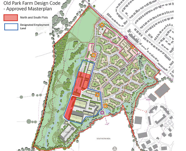
The Masterplan attached to the permission had regard to the Old Park Farm Design Code (approved March 2009).
The land designated for employment development included the North and South Plots, as well as the Waterlooville Household Waste Recycling Centre at the southern end of Darnel Road.
